Landform Interpretation
Objectives of Lecture
- Map Reading: making sense of contours
- Map Analysis: measuring slope gradient
- Map Interpretation: shapes and textures of geomorphic processes
Making Sense of Contours
Contour Interval
vertical spacing between contour lines
Index contour
provides (more frequent) reference to numerical value, every
5 or 10 contour levels...
Default rule
nested contours are "up" (at next
contour interval)
EXCEPTION: "depression contours" (hash marks
on down side)
Notches
contours bend inwards where a stream or valley cuts into a
hill
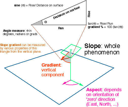
Slope (see readings on page 352-355)
Terminology:
Muehrcke uses "slope" for the rate of rise or fall
along a line; gradient for the steepest slope at a given point.
Uses slope orientation for direction of slope.
More common usage (in GIS):
Slope is a composite of gradient and aspect (orientation of
steepest slope), measured by the orientation of a plane tangent
with the surface.
Aspect: often a key factor in vegetation in mountain
environments (deserts too)
Estimating slope on a contour map
- Spacing between contours approximates slope gradient
- Count contour lines over a specified distance on the map
(make the calculation simple, pick a distance that divides neatly
into the contour interval...)
- Short distances work fine in steep terrain, gentle slopes
require longer distances, but then smooth out local variations.
Other topographic analysis
Trace ridges, delineate watersheds (nested as streams merge)
Interpreting Landforms from Contours
The Easy Stuff (often infrequent)
Depressions are rare:
- Volcanic craters, meteor impacts
- Karst (landscape formed by disolving limestone, forms caves,
water disappears down sinkholes, reappears randomly...)
- Sand dunes
The Regular Clues
- Texture
- Smoothness (regularity of contour spacing, rounded vs jagged)
- Relationship of landforms to streams
Some favorites
- Drumlin fields (ice advance)
- Chaotic drainage left after glaciers melt
- Linear features (San Andreas Fault, etc.)
- Karst (try to delimit watershed here!)
- "Mesa Country" (sharp lines between erosion and
deposition)
- Finding dry lake beds and lake shore features along the valley
walls
- Scablands (Eastern Washington dramatic flooding events from
ice dam breaks)
- ... and on and on,
Version of 24 January 2000