Objectives of lecture
Place as named "thing"
Places: not ordered, have to know where they are (so what kind of reference system can they provide to an outsider?)
Street signs: are they there to make the map correct? (part of a map-ground correspondence technology)
based on some clear choices and some arbitrary ones
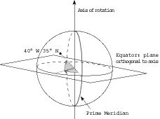
Polar axis of rotation: Establishes NORTH, Equator as plane at right angles
Latitude is ANGLE from Equator (North or South) (Parallels)
This was the easy part: shadow of stick at noon, Polaris at night...
Longitude: angle around Earth (Meridians), has to be measured from an arbitrary Zero (prime meridian)
Why Greenwich? (British made the bulk of nautical charts)
Notation: Bablylonian base 60: 127° 15' 00" = 122.2500 (decimal degrees)
These are ANGLES, distances vary northward (latitude vanishing to zero at poles)
Shape of the Earth? Topic considered later, latitude/longitude is basically spherical...
X,Y coordinates in distance units; attempt to flatten the Earth [see PROJECTION lecture next Monday]
Local: archaeological digs (grid of string); ecological study sites (grid of pipes)
125 zones across USA
Washington (and Oregon) have two zones ("North" and "South" for each state) Lambert Conformal Conic projection [see projections, of course]
Idaho has three Transverse Mercator zones (in North/South bands called East, Central, and West)
Distance on OLD version in feet (now meant to be in meters)
uses a methodical 6° band of longitude for each zone, coordinates always in meters
connects in military mapping to the Military Grid (a way to turn coordinates into a letter code)
16TCC0571 = 4771000 N, 305000 E
Computer Graphics are based on coordinates, but GPS (next lecture) may make latitude longitude the system of choice. The old reasons of simple calculation may not matter...
Muehrcke covers Public Land Survey and Land Records (hold these for later)
appears to be like a coordinate system, too many peculiarities to be treated mathematically.
Version of 25 January 2000