Objectives
Results were announced at last lecture. Exams were handed back and discussed (occupying the whole of the lecture period). If you missed this event, please try to find a time off-line to discuss the results.
Management has decided to add a second part to the midterm. It is DUE 25 February. This is not intended as make-work, but to clarify the intent of the midterm in supporting the class objectives.
A full lecture on GIS definitions from the Geog 460 class.
Proposed in Exploring GIS
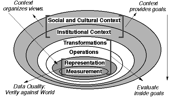
GIS: The organized activity by which people
These activities reflect the larger context (institutions and cultures) in which these people carry out their work. In turn, the GIS may influence these structures.
(presented from outside in)
Existing records must be made compatible. Soil erosion require six distinct 'layers' of information, measured differently.
Overlay, primarily. (prediction of soil loss and possible changes in farming practices)
Structure information resources to meet the objectives of the mandate. Unified spatial reference system had to be assembled, each source registered to a set of known points.
choices to obtain raw facts about environment to serve the purpose. Project relied on existing records: soils maps (many attributes attached to a set of zones), parcels, wetlands, etc.
Order of Magnitude improvements in geopositioning, automation,
interpretation and processing
Niemann, B. J.; Sullivan, J. G.; Ventura, S. J.; Chrisman, N. R., 1987: Results of the Dane County Land Records Project, Photogrammetric Engineering and Remote Sensing 53, October, 1371-1378.
Version of 10 February 2000