An object has one "special" attribute - its IDENTIFIER
Linkage from one object to another by reference to ID,
or through pointers to address in memory (pointers)
Objectives:
A data structure encodes a schema of the objects to be represented, their attributes and their relationships to each other.
Some simple data structures only allow one class of objects and their attributes, creating a matrix or "flat file" (see Brian Berry, 1964 Geographical Matrix). An example of this would be statistical packages, like SPSS.
As described earlier under methods of measurement (borrowing
from Sinton)
Space, Theme and Time: one can be measured if another is controlled
and the last is fixed.
RASTER : control space, measure attribute (theme) (TIFFs,
GIFs, JPEGs and image processing)
the basic unit is a PIXEL (a rectangular unit of space, coded
with some attribute value)
VECTOR : create OBJECTS that represent FEATURES, (based
on attribute)
measure their location. (PostScript ... and more)
This distinction used to separate the software solutions. Now
ArcMap does both. You have worked with the vector side (shape
files), but there is Spatial Analyst that works with GRIDs (raster).
Vector data structure follow progression of increasing complexity,
internalizing the logic
of map interpretation into the data structure -- increase in EXPLICIT
relationships.
Some storage of cartographic images is "no more structured
than spaghetti on a plate"
The image consists of lines and points which the reader must organize.
One advance is to store the polygon as object (see def. of
polygon)
This permits shading of the polygon (ArcView shape files and ESRI's
"spatial database" SDE - the high end product - computes
the topological relationships on demand from a shape file)
Problems: slivers between adjacent polygons because boundaries
not nec. the same.
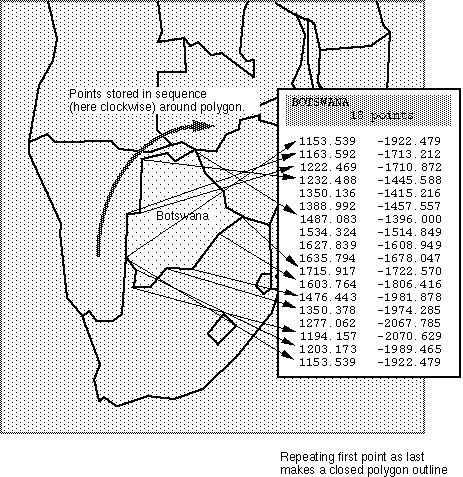
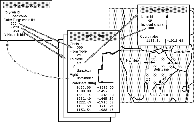
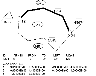
Organizes Points, lines and areas as nodes, chains and polygons.
Boundary and coboundary:
Provides for contiguity, better quality control, and other
features...
Examples: DIME (US Census), ODYSSEY and modern GIS (Arc/INFO "coverages")
Understanding Topology:
What it is NOT: Topography: measurement/representation
of earth elevation
and related features (a form of general/reference map)
Topology: study of basic spatial relationships based
on intuitive notions of space
(those not requiring measurements - just dimensions)
[the higher levels of mathematics of space (collectively called
Geometry):
Graph theory adds direction (even distances) to a network (still
based on connectivity)
Analytical Geometry: coordinate measurements; metrics of distance,
orientation
Differential geometry: projections
The basic spatial relationships: connectivity, contiguity