Error in maps: data quality and fitness for use
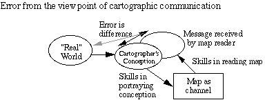
Error (mathematically) is the difference between a measured quantity
and its "true" value
(figuring out what is true is often not completely obvious...)
Maps can be tested by: internal evidence (repeated measurement),
comparison to source,
or comparison to an INDEPENDENT source of HIGHER accuracy
Distinction between precision (resolution of numbers, tightness
of internal distribution) and accuracy (relationship to
geographic entities, ability to replicate, etc.)
Components of Data Quality recognized by National Standard
for Digital Data Quality
Last four (IN CAPS) are testable, Lineage is not...)
Metadata Standard: another way of expressing the same things
Although the scheme above was adopted in a formal standard
(as SDTS,
ANSI/NCITS 320.1998), FGDC also adopted the Content
Standard for Metadata, which is in more practical use.
Resources on Accuracy
Standards on geopositional accuracy:
upcoming course: Winter 2004, Geography
458 Map Sources and Errors.
Version of 28 May 2003