A Revised Taxonomy of Overlay Combinations
Nicholas Chrisman, Geography
University Of Washington
Presented at Association of American Geographers meeting
in Fort Worth Texas, March 1997
Abstract
Overlay remains a central part in any rendition of the GIS
toolkit. No other operation acts so clearly to integrate diverse
sources of information. Over a number of years, a number of different
schemes have been articulated to explain the overlay operation,
most notably a 1975 paper by Hopkins and the map algebra advanced
by Tomlin. These frameworks do not provide an adequate explanation
of how overlay serves to integrate and what limits should be imposed
on its application. This paper presents a new taxonomy of overlay
combinations based on three groupings of operators: dominance
rules, contributory rules and interaction rules. Each rule operates
in the environment prescribed by an overlay: the geometric procedure
collects a number of distinct attribute values from separate source
material. With a dominance rule, one of these values become the
result based on some external rule, such as the highest value
for ordinal sources. A contributory rule uses all the source values
to construct a composite value where each value contributes to
the result equally. Addition is the simplest model, though far
from universally applicable. An interaction rule uses all the
values, but relies on the relationships between the values, not
just their numerical values. This new taxonomy offers an improved
explanation of GIS operations for education, training and an analytical
critique of GIS practice.
Outline of Presentation
- Why care about rules of combination?
- Review of literature on overlay in GIS
- Multi-Criteria Decisionmaking literature
- A New Approach
- Motivation from overlay problem (suitability)
- 3 classes of rules
Dominance, Contributory, Interaction
- Connection to transformations
- Overlay as simple case of transformation
- Role of attribute combination in
a generalized theory of transformations
Previous Literature on Overlay Combinations
- Lewis Hopkins (1977)
Methods for generating land suitability maps: A comparative
evaluation. AIP Journal
Taxonomy based on level of measurement:
Gestalt, Ordinal, Linear, Factor Combination, etc.
Strong caution about interpendence of factors
- Larz Anderson (1987)
Seven methods for calculating land capability/suitability
Planning Advisory Service Report 402
Pass/Fail screening, graduated screening, weighted factors, penalty
point assignment, composite rating, weighted compostie rating,
direct assignment
- Dana Tomlin (1982/ 90)
Map Algebra: openended rules of combination
Multi-Criteria Methods
For example: Benjamin Hobbs (1985) Choosing how to choose
(Env. Impact Ass. Rev. 5: 301-319)
"Amalgamation" (purpose to commensurate the incommensurable)
Defends commingling of attributes, but recognizes requirements:
1) "attributes" (variables/factors/maps) completely
describe impacts and characteristics of alternatives while avoiding
redundancy; values (importance) or prob. dist. known
2) all relevant alternatives be included (to be considered)
3) decision makers have stable preferences and can voice them
Steps:
1) attribute scaling: value-based midpoints/ tradeoffs
(conjoint measurement)/"holistic" scaling OR utility-based
indifference between midvalue OR p (better) · (1-p)
(worse)
2) attribute weighting: how much of one attribute to trade for
another
3) decision rule (procedure) from simple weighted addition to
fancy methods (ELECTRE)
Issue of "preference independence": are tradeoffs between
pairs of variables independent of third variables?
Applied in GIS:
Carver and Openshaw (IJGIS) Nuclear waste sites for UK
What is missing
- Students get lost in details
- Assumptions (axioms) not clearly stated as such
- Hidden assumption that "level of measurement" or
some other simple feature determines "correct" approach
A New Approach
Presented in Chrisman (1997) Exploring GIS [Wiley]
- Dominance rules
one value wins
- Contributory rules
each attribute contributes to result
(without regard for other values)
- Interaction rules
pairs of attribute values determine result
Examples of Combination Rules
Dominance Rules (one value wins)
- Exclusionary screening One strike and you're out.
Ex: WA Growth Management Critical Areas; PA initial phases of
screening
- Exclusionary ranking Extreme value from rankings (usually
worst wins)
USDA/ FAO site evaluations (slight, moderate, severe limitations)
- Highest bid Extreme value from continuous data
maximum profit at that site (best alternative); could be worst
highest risk
- Highest bidder Records identity of extreme value
Crop result from Thünen model
Independent Rules (all values contribute without regard for
the others)
- Voting tabulation Sum of binary exclusions
PA low-level waste siting process
- Linear combination Sum of 'ratings' (mean, etc.)
Dane County Solid Waste Plan (added up ordinal values...); METLAND
added $
- Weighted linear combination Weighting and rating game
LESA, Kansas
"Linear Combination" - the Weighting and Rating Game
Vj = Sum (wi rij) / Sum ( wi )
influence of roundoff (integer values) on ratings and
weights
standardized ratings make weights easier to understand
Independence of factors
When the variables are continuous, suitability might have
some functional form; total cost, elapsed time, ... which is
not simply an average; it could be a total.
- Product Multiplication of factors
Interaction Rules (pairs [or more] of values are consulted
to yeild the result)
- Gestalt (Integrated Survey) Informal judgement
- Factor Combination Rank with conjoint measurement
- Rules of combination Formal interaction tables
- Threshold formulae Divided phase space
Three Classes of Rules
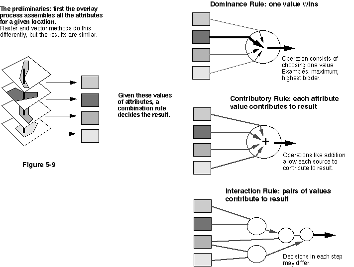
Connection to transformations
- Overlay as special case
Geometric procedure assembles all the attributes for a given
location.
Rules of combination produce a composite result.
- Framework for transformations:
Combination of neighborhood (geometry)
and rule of combination (attribute)
Handles buffers, interpolation, iterative procedures, etc.