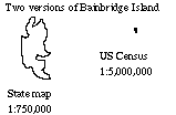
Generalization and Scale-changing


Basic conversion: rich, detailed data sources selectively represented (re - presented...) for different purposes at more and more generalized scale.
Generalization is a general process of limiting the information on a map.

Connections to previous lectures:

part of the process of compilation

an example of the transformations of analytical cartography


The physical limits of the graphic medium used to control the process,
the computer makes it more self-conscious.


Components of Generalization

(as given by RSMM)
As with Graphic Design: Elements (tools) and Controls (constraints)

ELEMENTS of generalization

Simplification : "Radical Law" of diminishing number of features
Classification: grouping of information, based on hierarchy, similarity, "typical" value...
Symbolization: replace geometric representation with symbol (roads, streams, cities)

Induction: "logical geographical inferences"

CONTROLS of generalization

Objective
Scale
Graphic Limits (see design constraints...)

Quality of Data (see accuracy lecture)


Another framework for generalization (Kate Beard 1990)

Operations to reduce the numbers of objects
Operations to simplify the spatial information
Operations to simplify the attribute information
Plus all combinations

(reduce numbers and simplify one, simplify two, all three, etc.)

Procedures for Scale-Changing (after Kate Beard PhD)

SELECT (reduce number of objects)

Geometric criteria: length, width, area, min/max...

Attribute information: contents, neighbors, ...

AGGREGATE

Eliminate classes in a categorical scheme,

Reduce continuous measures to ordered categories (Class Interval Problem)

REDUCE (simplify geometry)

Remove geometric detail: Douglas algorithm is fine, based on lots of studies (not perfect, but as good as one can expect)

Douglas Algorithm: based on trend line and deviation from it - recursively applied


COLLAPSE (reduce number of objects and simplify geometry)

Convert the geometric dimensionality of an object:

Small areas turn into point symbols, Thin areas turn into lines...

COARSEN (reduce number of objects and simplify geometry)

Area simplification based on Epsilon filter (conceived by Julian Perkal 1956)
Implemented by ODYSSEY software (Harvard Lab for Computer Graphics, Dougenik and NC)
Conceptually, roll a ball of chosen width along the line, center of "sausage" is generalized line.

Operationally, find all points within tolerance and collapse to one rendition.
(Example of Pittsburgh land use and Coast of Maine)


McMaster and Shea

philosophical
application

computational

conditions
measures

controls

procedures & transformations
Simplification, Smoothing, Aggregation, Amalgamation, Merging, Collapse, Refinement, Typification, Exaggeration, Enhancement, Displacement, Classification... (and more)


Some links to generalization issues:
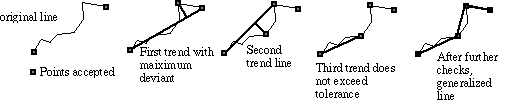
The Douglas algorithm from the horse's mouth

International Cartographic Asociation Working Group on Generalization
University of Zurich research group (some of their current projects)
QTM Comix (G. Dutton) (more QTM)
AGENT site (Institut Geographique Nationale - France)

Version of 16 May 2001