Geog 460 - Autumn 2003
Exercise 1: ArcGIS, Spatial Analyst & Measurement
Due date (due at the beginning
of your lab section):
AA, AB, AC on October 15
AD, AE, AF on October 16
Objectives:
- Master
ArcMap/GIS Help.
- Investigate
measurement frameworks in the BainbridgeIsland data set.
- Exposure
to the functional abilities of Spatial Analyst.
To help you understand this lab,
please be familiar with the following readings:
How
To Save Your Work
Exploring
Geographic Information Systems Chapter 1
Exploring
Geographic Information Systems Chapter 2
Reference
Systems (Lecture 3)
Measurement
Levels (Lecture 4)
Measurement
Frameworks (Lecture 5)
More
Measurement Frameworks (Lecture 6)
Exercise 1 Deliverables:
Completed answers to the questions
in Parts A and B. Please answer the questions in your own words;
please use the answer sheet
(download it and print it out).
Part A: Arc GIS Survival Skills
In this section you will review
some important concepts (ArcGIS
Survival Skills). These questions have been designed to
emphasize a few fundamental elements of ArcGIS that will help
you succeed in later exercises. You can find the answers in the
ArcGIS Survival Skills and the ArcGIS help systems. You
may have to explore several Help windows in order to respond to
a given question. If you reference commands or operations in your
written replies, please be specific about which windows and/or
menu items are involved.
Question A1: What type of
file is an ArcMap project file (.mxd) and what information
is stored in it?
Question A2: What is an Extension and how do you
load one?
Question A3: When working with Spatial Analyst extension,
what is the default working directory setting and how can
you set it?
Question A4: Describe the differences between raster
and vector spatial data formats.
Question A5: What types of files comprise a layer?
Question A6: Should you use Windows to move a grid data
set? Explain.
Part B: Discerning Measurement Frameworks
In this section you will open an
ArcGIS project and begin exploring the Bainbridge Island data
set. Following the instructions on file management and saving
your work will help prevent many difficulties as you work in ArcGIS.
The data exploration steps in this section will help you prepare
for Discussion 1.
Examining data
1. Please read and make sure you
understand How
To Save.
2. You should already have a folder under P:\Students with your
UWNetID as its name. If you dont have one yet, ask your TA.
3. Create a new folder with the name ex1. Copy the Ex1.mxd
project file from P:\geog460aut03\Exercises to your working
directory. (Thus, if your UWID is "jdoe" , then you
should now have the project file in the following path: P:\Students\jdoe\ex1).
[If you open the common copy, it gets locked and no one else can
touch it!]
4. Start ArcMap and open the ArcMap project in your \ex1 folder
(e.g. P:\Students\ jdoe\ex1\Ex1.mxd)
5. The Exercise 1 Project comes with two
data "themes" already loaded:
bi-soil
img-NDVI1998
To see the source of the layers, right-click
on the layer name, go to Properties->Source.
Right now the datasets are on the read-only
folder, so if you want make changes to the data, or you want to
take the data with your project back home, you need to copy the
source data to your own folder (or zip disk) and reset the data
source.
6. Select the bi-soil
theme by clicking on the theme and display it by checking the
box next to its name. [Remember how to select various attribute
fields for display.]
7. Use the identify tool  and click on several soil polygons to see
their attribute values.
and click on several soil polygons to see
their attribute values.
8. Close the Identify Results dialog box.
9. Open the bi-soil theme's attribute table by right-clicking
on the theme name, then selecting Open Attribute Table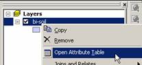 to see data for all items in the theme. Each column
can be selected for distinct display, using an approriate classification
scheme for the data.
to see data for all items in the theme. Each column
can be selected for distinct display, using an approriate classification
scheme for the data.
Question B1: How do
you know if this theme is raster or vector?
Question B2: Are the elements in this theme isolated
or connected?
Question B3: Of space, time and attribute, which
is controlled, which is fixed, and which is measured?
Question B4: What are the levels of measurement
(Steven's
scales and more) for the attributes: K_value, Identifier,
and Id_slope.
(For some assistance related to K
factor, see the Soil
Survey Manual online; and some additional documentation
on Universal Soil Loss Equation.)
Question B5: Which of the measurement frameworks
covered in Chapter
Two best describes the data in this theme?
10. Select and display the
img-NDVI1998 theme.
11. Use the identify tool and open the theme table to
explore the data of this theme.
12. View the Metadata for the dataset by opening Arc Catalog
Question B6: How do
you know if this theme is raster or vector?
Question B7: What do the "pixel values"
of the cells represent?
Question B8: Is the data in this theme isolated
or connected? (Trick question)
Question B9: Of space time and attribute, which
is controlled, which is fixed, and which is measured?
Question B10: What are the levels of measurement
(Steven's scales and more) for the attributes:
Value and Count (See Steps 11 &12 ).
Question B11: Which of the measurement frameworks
covered in Chapter Two best describes
the data in this theme?
Version of 27 October 2003