Supporting Resources
Index of Resources:
Citations to literature implied in lecture
The division of maps into general and thematic dates back to
the first half of twentieth century.
- Raisz, E. 1948: General Cartography. New York: McGrawHill.
- Raisz, E. 1962: Principles of Cartography. New York:
John Wiley.
The division continues in the basic texts on cartography (such
as:)
- Robinson, A. H. 1953: Elements of Cartography. New
York: John Wiley, first edition.
- Robinson, A. H., Morrison, J. L., Muehrcke, P. C., Guptill,
S. C. and Kimerling, J. 1995: Elements of Cartography.
New York: John Wiley, sixth edition.
- Dent, Borden, Thematic Cartography (three editions...)
John K. Wright (originator of "dasymetric" mapping)
had a much more creative view than the rest of the folks at the
time...
- Wright, J. K. 1936: A method of mapping densities of population
with Cape Cod as an example. Geographical Review 26:
103-110.
- Wright, J. K. 1955: "Crossbreeding" geographical
quantities. Geographical Review 45: 52-65.
Recognition of Fixed, Controlled
and Measured, David Sinton:
- Sinton, D. F. 1978: The inherent structure of information
as a constraint to analysis: Mapped thematic data as a case study.
In Harvard Papers on Geographic Information Systems, 6
, ed. G. Dutton, p. 1-17. Reading MA: Addison Wesley.
Treating Time and Space together:
- Hägerstrand, Torsten 1970: What about people in regional
science? Papers of the Regional Science Association 14(7):
7-21.
Components of Geographic Information
Time, Space and Attribute:
fairly common division in geography; lots of controversy about
"absolute" versus "relative" spaces
Space-time diagrams have remained
a textbook exercise, largely. One
artist has created a neat set that represent her week in Minneapolis.
Divisions between time, space and attribute are practically
more complicated: attributes are often about time, clocks are
used to measure space (astronomically); we use time to describe
distance (assuming that everyone has a motor vehicle)...
Resources on Reference Systems
Reminder: A reference system incorporates a package of decisions
about measurement of some property; it provides a means to compare
things (at the simplest level).
Temporal Reference Systems
- Clocks
- The number system: Egyptian? Babylonian? heritage (base 12
and base 60) hours, minutes, seconds [a very old technology,
linked to astronomy]
- Technology of time-keeping:
- Books:
- Crosby on time in middle ages
- Latitude by Sobel: chronometer in 18th century
- Network Time Protocol clocks (mean versus siderial times
relate to astronomical basis of observations):
- Universal
Time from US
Naval Observatory
- right
now at UW
- Distinction between "mean" time and siderial time,
a calculator,
to confuse you completely)
One explanation of the differences between them. Another description
of the Equation
of Time (relation of solar time to mean time)
- Calendars (see a more exhaustive description of types)
- Solar (eg. Gregorian
365 days, leap year rules, etc. )
- Roman origins: base dates: "ab urbs condita"
(founding of Rome); 1 AD = 754 AUC (set by Dionysius
Exiguus in 547 AD)
- Julian
calendar (Julius Caesar) had basic leap years every 4
- Gregorian
(Pope Gregory) refined leap years 97 in 400 years; originated
in 1582
- required dropping 10 days, so 15 October followed 4 October.
- BUT not adopted uniformly - Geography of calendar
conversion
- Countries converting later had to drop more days
- (eg. "November Revolution" in 1918 Russia)
- Then the age-old problem of formatting dates
- "American" mm/dd/yy
- "European" dd/mm/yy
- "international"
ISO 8601 CCYY-mm-dd
- Revolutionary
France started a new origin (Year 1 retroactively the adoption
of the Convention in 1792), uniform 40 day months, 10 day "weeks"...
Napoleon reinstituted the conventional calendar after a few years
(1806). Another resource
on the revolutionary calendar.
- And when did the Millenium start?
- The Greenwich
case...
- Lunar
- Islamic
calendar is purely lunar 12 months (moon cycles) of 29.53 days
= 354.36 days per year. Year 1: Flight of Mohammed to Medina
(Hijra), 1 AH (622 AD). 2000 (gregorian) was AH 1421 (though
622 is only 1378 solar years); the year is of different length...
- or a lunar
calendar with 17 months and leap year every 50 years...
- mixture of lunar and solar
- Hebrew
calendar (with leap months)
- Israel officially uses the religious calendar, but operates
on Gregorian.
- Chinese
calendar (predates the Romans)
- Scientific calendars
- Gregorian calendar basically counts DAYS, based on "universal
day" (Julian)
- So did the Mayans'
Long Count
- Geological dating (BP: Before Present): 1950 established
as "Present"
- Groups advocating calendar
reform.
Spatial Reference Systems
A spatial reference system includes:
Units of measurement (along the axes)
Projection
Ellipsoid
Datum
(usually includes a specification of an ellipsoid)
These decisions are often packaged up into a conventional
coordinate system (spatial reference system) such as UTM or
State Plane (in the USA) [Including the Washington
Coordinate System established by state statute], or various
national grids elsewhere (UK
National Grid, France Grille Lambert, Germany Gauss-Krueger, Finland
etc.). Many maps (such as USGS topographic quadrangles SHOW multiple
coordinate reference systems: they are only constructed in
one of these...). Australia has a number of spatial reference
systems AND some
neat tools to convert between them
A full coverage of issues of geodetic
datums {Geographer's Craft Project]; Geodesy
for the Layman (NIMA) other NIMA Geodesy
publications; the current accepted world standard WGS
84
Resolution of coordinates not entirely identical to scale (in
traditional sense) - but this is an issue of representation (covered
in Chapter 3)
This topic becomes a much more central component of Geography
465 (winter 2005)
Attribute Reference Systems:
Systeme Internationale d'Unitiés (SI):
codified by international agreement in 1875. Colloquially referred
to as the "metric system" in the USA (it is actually
official,
despite our day-to-day lack of metric units).
Defines seven base units:
| meter |
length |
| kilogram |
mass |
| second |
time |
| kelvin |
temperature |
| ampere |
electrical current |
| mole |
chemical quantity |
| candela |
intensity of light |
More on SI, base units, conversion
between units, etc.
Using these base units, many physical quantities are expressed
in "derived" scales explicitly (as in meters per second
(velocity), meters per second squared (acceleration), or in units
like feet, hours, hectares, acres, watts, newtons or joules that
are defined by some formula based on the base units.
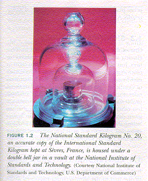
US Office
of Weights and Measures (National Institutes of Standards
and Technology (NIST) was called Bureau of Weights and Measures)
Historical note
Civilization (meaning organized human activity including as
commerce, science, political authority) has depended on sharing
systems of measurement. Standardized weights and measures are
found in some of the oldest city excavations. Emperor Qin unified
China in 210 BC and one element of his administration involved
standardizing measurement across his empire. This may seem totally
obvious in our modern life, but measurement is technology...
From here: Back to Lecture 03
| Class Resources | Lectures
| Exercises and Discussions | How to contact us
Version of 24 October 2003