Course Organization
There are a number of models to run a course. Some common ones for GIS curricula,
along some additional concerns that influence the schedule of events in
a term. The text Exploring GIS organizes its presentation in a somewhat
non-traditional ring-like sequence, moving from measurement through representation
to operations and transformations, then out to issues of greater context.
This order will be given the most attention, but first some other possible
orders deserve attention.
Input, Processing and Output
Any GIS application can be described in terms of input (the source material),
processing (what you do to it) and output (what you wanted to make). Early
conferences, such as the first AUTO-CARTO in 1974, organized sessions in
these categories and in this sequence. As a sequence it links the course
sequence to replicate a project or application. A number of textbooks and
course materials have adopted this sequence, consciously or unconsciously.
The text Exploring GIS can be used to support this kind of sequence. Part
1 deals largely with information resources and Part 2 deals with the processing
possibilities. Part 3 does treat the consequences and context of GIS. Still,
the text does not create as linear a path as would be implied by the typical
flow chart.
To use Exploring GIS in the input-processing-output sequence, Chapter 3,
in dealing with representation introduces digitizing input as a process.
Chapters 1 and 2 would have to be treated as background and introduction.
Part 2 presents the processing steps. The risk of this sequence is that
teaching about the input process requires a mention of many transformations
and operations that have not been introduced or explained. Decisions about
database design cannot be taken until one understands the processing technology
and the desired output. Still, one way to teach GIS immerses students in
a real-life project that will forcibly follow a sequence of input, processing
and output.
Problem-driven Courses
A problem-oriented course takes a project as the focus and teaches the technology
as it applies in that larger purpose. Such a course would typically spend
time at first defining the problem, and designing the results desired. Some
of these issues would engage the social and institutional aspects of GIS
discussed in Part 3 of the text. When the GIS technology is introduced,
the measurement questions can be addressed for the specific project, leading
into the input procedures as a means to represent the required information.
Part 2 can be used as a resource, selecting those procedures required for
the project.
Technology-driven Sequences
Another way to teach GIS focuses on the technology. Often these courses
are taught following the tutorial for a specific package, or using user's
manuals as the only readings. Certainly there is a need for training in
these GIS packages, but many of the decisions involved in using the software
make little sense when presented as a series of optional commands or macros.
Attacking the user's manual in alphabetic order is hardly an optimal design
for instruction. Tutorial courses may walk through a project in sequence,
but only discuss the concepts directly related to the task at hand.
It is a very difficult task to cover the complexity of a full-featured GIS
package within the confines of a regular university term. A regular university
term may provide forty or fifty hours of contact time. If there are thousands
of commands to present, the instructor could only spend a minute per command,
no matter how complicated. The only solution is to be selective, and to
organize the sequence in some other way than the vendor's organization.
A strong background in Part 1 on measurement frameworks should help in explaining
why a particular package is organized as it is. Then a cluster of commands
can be treated as a unit, following the sequence in Part 2. Though the technology
does not directly address the issues in Part 3, students should have the
chance to think about those issues and how they influence applications.
Measurement, Representation, Operations, Transformations
and Context
The ring structure [diagram from Preface p;
Figure 0-1] of Exploring GIS suggests a modification in course sequence.
With the resources in this Instructor's Manual, it should be possible to
adjust a previous course design to harmonize with the sequence in the text.
The ring structure of Exploring GIS can be summarized by the definition
found in Chapter 1.
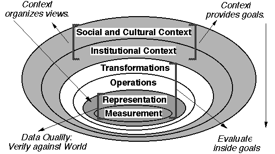
A Geographic Information System (GIS) can be defined as:
The organized activity by which people
- measure aspects of geographic phenomena and processes;
- represent these measurements, usually in the form of a computer
database, to emphasize spatial themes, entities, and relationships;
- operate upon these representations to produce more measurements
and to discover new relationships by integrating disparate sources; and
- transform these representations to conform to other frameworks
of entities and relationships.
These activities reflect the larger context (institutions and
cultures) in which these people carry out their work. In turn, the GIS may
influence these structures.
A course sequence, like the pages of a book, forces a linearity on topics
that might be far from linear inherently. The ring diagram provides a way
to show how detailed decisions get embedded inside larger issues. A course
sequence can refer back to the nested rings when some topic is mentioned
before it has been introduced.
The measurement ring serves as the start. Chapter 1 reviews material usually
covered in earlier courses, with some new developments. Yes, the treatment
of levels of measurement is different from the one that is commonly accepted.
Chapter 1 concludes with reference systems for time, space and attribute.
The measurement frameworks in Chapter 2 provide a basis for describing operations,
and particularly transformations (a key to Part 2). Chapter 3 moves from
the concept of a measurement procedure to the details of a particular representation
in a computer. It may make sense to only cover the digitizing section in
Chapter 3 lightly in the first reading, then to return to that topic when
Chapter 9 on transformations provides a more complete coverage of conversion
between various measurement frameworks. Part 2 follows a fairly consistent
sequence from the simple to the complex. Other textbooks have presented
various frameworks for such a sequence, so this one should not seem unfamiliar.
Some of the terms have been reconsidered to make them as consistent as possible.
Chapter 8 serves as a linkage between iterative operations usually considered
a part of GIS and more comprehensive operations often considered in other
courses.
Part 3 places GIS in a larger context of economics, institutions and society.
These issues might seem out of place in a technological methods course,
but they may help spark some reflection by students. Most practitioners
of GIS understand that there are many issues decided on non-technical grounds.
Part 3 may not need any exercise material, but it should play some role
in lectures and discussions at the end of the course.
Interdisciplinary connections and prerequisites
All courses depend on the existing knowledge base of the student, even at
the elementary school level. Teaching about geographic information systems
requires some knowledge about the basics of maps. In a geography department,
there is usually a course on thematic map design, perhaps preceded by a
course on map reading. My course on GIS Analysis presupposes a cartography
course consistent with the map design/map construction intent of Robinson's
Elements of Cartography or similar texts. Eventually, the coursework
on quantitative methods, research technique and mapping may merge, as it
has on a few campuses. The GIS perspective may move earlier in the curriculum.
It should be possible to use Exploring GIS in such a role, if there
is some treatment of basic geodesy (latitude, longitude), and map representation
provided as a supplement.
Ideally, the student entering a GIS course should have some experience in
making a map directly from field observations. This is common in British
geography, but rather rare in the United States. Students from field-based
disciplines (soils, geology, agronomy, botany and many more) are thus better
prepared for some aspects of my course than my geography students. I try
to encourage a mixture of disciplinary backgrounds, even when the geography
students fill the available slots to overflowing. Students with different
field experience help explain the special character of input from their
disciplines. They are often highly motivated to use GIS analysis in their
own research problems. It may take some translation of terminology to explain
a choropleth map to a forestry student, but there is usually some cognate
situation that makes sense in the other discipline's repertoire.
This course sequence should also work for teaching GIS outside of a geography
department. The first five years I taught this course, I was in a Landscape
Architecture department housed in a School of Natural Resources in a College
of Agriculture. I had a few geographers, but most students had no geography
coursework at all. The site analysis course in Landscape Architecture served
as the background in fieldwork and mapping quite well, though it provided
rather little about world map projections, it did cover projections through
perspective drawing of near-scale environments. The basic concepts of geometry
are not the special territory of any discipline.
Most social sciences have been influenced by Stevens' levels of measurement.
If your students have been exposed to basic statistics in a social science
they will probably have learned the Stevens framework (nominal, ordinal,
interval, ratio). Chapter 1 is directed to open student's minds to the possibility
that the classical four level taxonomy is not complete. The treatment in
Chapter 1 may be longer than you want to spend on the subject p; it
often gets a page or so in cartography textbooks. I fully expect that some
research professionals will continue to use the four levels despite my arguments
about expanding the scheme. Thinking about measurement carefully should
help in teaching the later stages of representation.
Some students with training in the biological or physical sciences or in
purely mathematical statistics might have been trained to approach measurement
differently. For this group of students, the Stevens taxonomy might seem
like a dead horse that deserves little attention. Chapter 1 should be presented
to this group simply as a curious set of terms commonly used in the mapping
disciplines. The concept of control that motivates Chapter 2 should fit
into many different disciplinary trainings for field measurement.
Computer Background
At one time, a GIS course would be filled with students who had never used
a computer before. Eventually, the computer itself ceased to be a novelty.
Thus, the need to worry about computer experience has become less critical.
Still, many students will have limited experience on the particular operating
system of your lab equipment, and some will be quite nervous about the 'technical'
details. I have used the campus short courses and workshops to help some
students, and I still design the early portion of the class to provide nurturing
and assistance in the lab sessions. A formal prerequisite for computer science
classes should not be required.