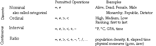
Stevens' four levels of measurement are the common background for measurement in geography and cartography.
Variants of nominal categories: sharp sets (perfect boundaries), 'fuzzy' (% membership) or 'prototype'
Objectives of lecture:
The main key to an effective map is by matching the graphic treatment to the attribute.
Stanley Stevens (1947) distinguished four (4) "levels of measurement" largely as a way to decide what kind of statistics were applicable.
Cartographers adopted Stevens' "Levels of Measurement" as the framework for cartography, it works (mostly, to some extent...).
An example:
Stevens' four levels of measurement are the common background
for measurement in geography and cartography.
Variants of nominal categories: sharp sets (perfect boundaries),
'fuzzy' (% membership) or 'prototype'
Examples:
Distinction between "raw" and "derived" (comaparibility for different "sized" spatial units) eg. population versus population density; David Douglas (and many other cartographers) call this "absolute" and "relative" - see his treatise on the distinction [temporarily offline, pardon the inconvience].
Absolute level (0 and 1 fixed) as Probability
Counts (real zero - just like Ratio, but discrete [no
half people] and units are not arbitrary);
Cyclical measures (such as wind direction, clocks that just repeat)
Dent has some attempts to cover this division with his "natural"
and "artificial" areal units (page 76), but that scheme
does not stand up to all kinds of thematic maps...
Sinton characterized thematic mapping information involving three
components:
Location, Theme (Attribute) and Time (see last
lecture)
In order to measure one, one must be fixed and one
"controlled": for example...
Control: attribute; Measure: location
Isolated Objects
- Spatial Object Single category distinguishes from void
Control: identity of object; Measure its location (edge)
- Isoline Regular slices of continuous variable
Control: fixed heights; Measure location of that valueConnected Objects
- Network Spatial objects connect to each other, form topology
- Categorical Coverage Region subdivided by exhaustive classification
Control: location (grid); Measure: Attribute
Many variants, but cells (pixels) are spatially uniform, each recording an attribute value...
Choropleth Collection zones used to tabulate more primitive attribute objects
First: Control: identity of object; Measure its location (edge) => base map
Second: use base map objects as Spatial control; Measure attribute within objects.
Control: Time (hour) Measure: Attribute (water level) => strip chart (tides) [overhead]
Control: Poland@date Measure: location => Historic Poland, [wall map]
Interaction data such as international trade, interegional flows ($, commodities or people)