GIS Analysis: expectations for the class
Objectives of lecture:
- Present Syllabus for class
- Ring diagram (see text Preface Figure P-1)
- Present an application (Dane County Land Records Project)
Syllabus: WEB-BASED.
Web pages contain lecture notes, exercises, case studies and pointers
to other resources (data, explanations, etc.)
http://faculty.washington.edu/chrisman/Geog_460.html
Textbook:
Chrisman, N.R. 2001: Exploring
Geographic Information Systems, (second edition) John Wiley
Comments from students strongly
encouraged!
Ring Diagram
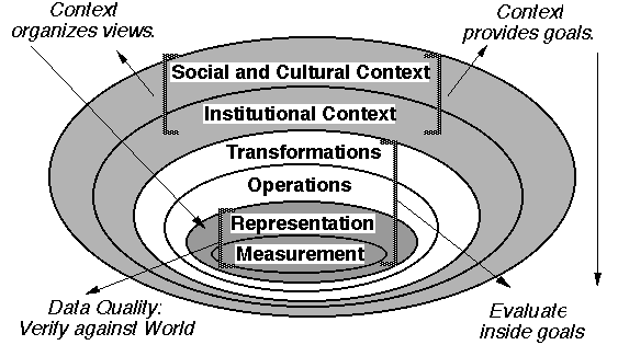
Geographic information has a number of distinct 'levels' of analysis.
Some courses follow a work-flow, leading from input to processing
to output.
Such an organization focuses on what is done, not why is it
done.
This course adopts a nested set of concerns, each influencing
the others.
Outwards: measurement, representation, operations, transformations,
context.
Dane County Land Records Project
in answer to the question: "What is this course about?"
It is about EACH of these layers, but they are built upon each
other.
(presented from outside inwards)
Social Context:
- Society (politics, media, etc.) has become aware of soil
erosion produced by farming practices.
Institutional:
- Legislature created a mandate requiring counties to produce
a plan to meet certain soil erosion goals by a given date.
Information component
- 1982: Most counties proceed using manual methods, in Dane
County, University of Wisconsin attempts to demonstrate GIS (still
experimental at that time)
Transformations:
Existing records must be made compatible. Soil erosion require
six distinct 'layers' of information, measured differently. Result
desired is AVERAGE soil loss over a parcel, not in the physical
units measured.
Operations:
Overlay, primarily. (prediction of soil loss and possible
changes in farming practices)
Representation:
Measurement:
choices to obtain raw facts about environment to serve the
purpose. Project relied on existing records: soils maps (many
attributes attached to a set of zones), parcels, wetlands, etc.
Bottom Line:
Order of Magnitude improvements in geopositioning, automation,
interpretation and processing
For further reading, begin with:
Niemann, B. J.; Sullivan, J. G.; Ventura, S. J.; Chrisman,
N. R., 1987: Results of the Dane County Land Records Project,
Photogrammetric Engineering and Remote Sensing 53, October,
1371-1378.
Index from Here: | Introduction to Lab
Sections | Course Policies | Next PART of Lecture | Schedule of
Lectures | Labs
and Due Dates | How to
reach us
Version of 25 September 2003