Objectives of Lecture:
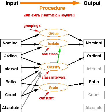
These operations reduce the information
content by collapsing many categories to one [or
to fewer...] (Group, Isolate - which does it in the BACKGROUND
category) or by collapsing higher level measurements into ordinal
(Classify). The red text above identifies the external
information required to make this happen.
There are many rules for classification (remember
the 360 lecture on the topic).
Scale reduces information only if the resolution
of the scale is altered (an issue of representation), otherwise
a scaling changes no information.
Even these simple operations produce results that influence the
apparent measurement framework. Aggregation occurs
when the aspatial groupings of attributes require a geometric
process to remove boundaries which are now internal to one category.
Often called 'dissolve' or 'drop-line' aggregation.
Isolation of a single category can change from an exhaustive
categorical coverage to an isolated object view, but the decisions
made on the original coverage provide the geometric representation.
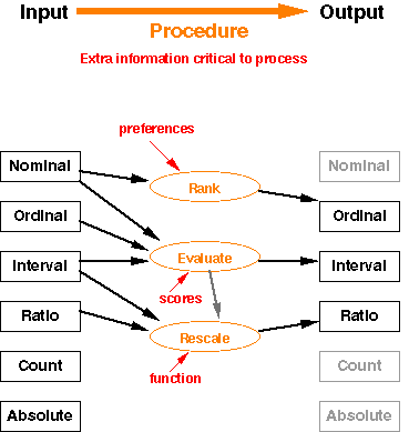
Increase in information content comes from external assumptions or judgements. With a source of preferences, you can order categories. With a set of scores, you can assign numbers to categories. With a non-linear function, you can rescale numbers. These are not inherent in the attribute reference systems you have to start with. They come from understanding something outside the numbers you have. (These are the holes in Stevens' system!)
Examples: King
County use of Public
Benefit Rating System (look at 20.36.100, page 82-3 of the
122 page document)
| Ecology Wetland
Rating System ; (69 page .pdf; look at pages beginning at
33 for the form, 44 for the defintions of Classes) ; applied to
Eastern Washington
| Timber
Site Index |
Operations on attribute values take one set of attributes and
give you new "columns". How this is implemented depends
on the data representation.
Vector implementation with attribute
tables make these distinct, but in raster systems, pairs of values
invoke overlay methods (Chapter 5).
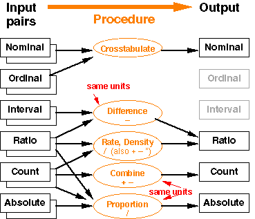
Crosstabulate, Difference, Rate, Density, Add, Subtract, Proportion,
etc.
If you have pairs of values for the same set of objects (representation),
you can generate new values that depend on PAIRS of values.
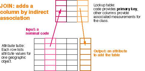
The 'attribute' provides a foreign key to a lookup table
of attribute values. This process is called JOIN in a relational
database package. The Washington
State Timber Site Index is assigned from a soil class to create
the Land Grade Classes for taxation purposes (indirect measurement
a few times in a row...) [WAC 458-40-530].
Index from Here: | Next Lecture
| Schedule of Lectures | Labs
and Due Dates | How to reach us
Version of 15 October 2003