Example: Amazon basin used for classic purpose to estimate rainfall input from weather stations
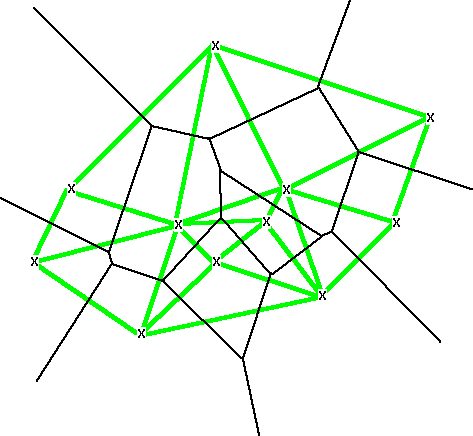
The Delaunay trinagulation (thicker grey lines) is the network of the connections between points that have a nearest neighbor relationship.
Objectives of Lecture:

In either case, the edge of objects form the basis for sending
a contour outwards or inwards.
A fixed distance is used in place of a more careful study of the
actual hazard/risk. [See an example
about a series of studies in Illinois locating landfills]
Example: Timber, Fish Wildlife Agreement, Washington State
Riparian Management Zone (RMZ) Requirements
Water Type & Width    Maximum RMZ Width
Class 1&2  >75'            100'
Class 1&2 <75'              75'
Class 3 > 5'                50'
Class 3 < 5'                25'
Note: a minimum width of buffers is set to 25' for all water types and widths. Classes of water are defined in WAC 222-16-030. Source: WAC 222-30-020 (4c)
Vector: fixed distances create contours (isolines of equal distance) gives a precise location for a specific regulation, gives zones between...
Each segment throws out a zone around it (two half circles and one rectangle).
To generate a buffer, construct these objects around each segment, overlay all the objects, aggregate to remove duplicate areas.
See Figure.
measures distance to center of each cell, comes in steps of cell width
Each cell is exactly one cell width away, shorter distances
cannot be detected (resolved). Diagonals can be estimated from
Pythagorean theorem, see Figure.
Results of a distance measurement
- Amazon project in Oceanography UW : Distance from mouth of Amazon;
- Wilderness Quality Mapping (Arctic Scandinavia)
- Are you closer to a wetland or a road? (subtract the two distance surfaces)
Post-It Notes, parallel 'computer' simulation
Voronoi network (dark thinner lines) divides the region into
areas closer to a particular point than any other (formed by pendendicular
bisectors of lines between neighboring points).
Example: Amazon
basin used for classic purpose to estimate rainfall input
from weather stations
The Delaunay trinagulation (thicker grey lines) is the network
of the connections between points that have a nearest neighbor
relationship.
Beyond Voronoi: "Extended" neighborhoods for non-point
objects (lines forming polygons)