Tables 9-1 and 9-3 are four by four matrix with measurement
frameworks as the rows and columns.
The four frameworks are defined as follows:
Isolated point objects with a measured height of the surface.
The location of the point is measured (free to vary), and
the control comes from the identity of the point.
Contours of the surface established by controlling height
and measuring where that height intersects the surface.
(Digital Elevation Matrix) a space controlled framework
of point height in a regular grid.
(Triangular Irregular Network) a coverage of triangles connecting points with Z values so that the triangles define areas with a constant slope (gradient and aspect)
You can have a representation that appears to be scattered points but it those points come from contour lines, they still have controlled heights.
A TIN created from a DEM still has controlled positions.
and so on.
The Surface Network does not provide complete representation
of a surface, but might be included to show some additional forms
of transformation.
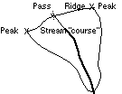
This network defines watershed boundaries by tracing the ridges,
or 'hills' by tracing the courses (extended up to passes). The
nodes in the network are Peaks, Pits, Passes and Pales (the definition
of the later is a bit tricky - the points where a ridge descends
to a courseline).
Operations to create watersheds from a terrain representation
are a level of transformation beyond what is described in the
matrix. You cannot go back to the terrain detail from the watershed
boundary.