Measurement Frameworks
Objectives of lecture:
1. Revisit Pop Quiz in last lecture
2. Measurement as a set of choices about the basic three dimensions
- Roles: Fixed, Controlled, Measured
- Examples of these choices
3. Indirect Measurement and Composite Frameworks
4. Connections to Labs
Basis for any formal theory (database,
etc.)
Two ways of stating it:
entities, relationships and axioms (mathematics)
objects, relationships, integrity constraints (Codd's relational
database design)
An axiom
is asserted without proof; an assumption
A data model
specifies:
- the objects that are recognized,
- the relationships that are possible,
- inside a set of integrity constraints (expectations).
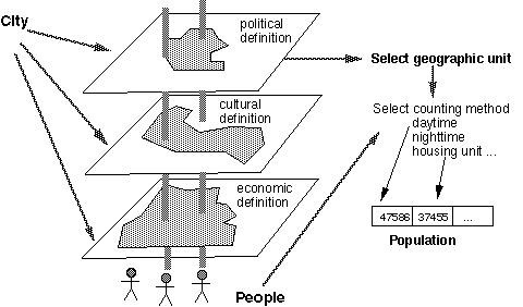
Basic Measurement Framework: The Geographical Matrix
Geography has a set of "things" (places) and each
"has" certain attributes.
Thus a simple matrix (cases and variables) serves the model...
| City Name |
Population 1990 |
% Office Vacancy |
Debt/ Person |
Rainy Days |
| New York |
7072000 |
18.1 |
$4778 |
111 |
| Los Angeles |
3485000 |
14.3 |
2296 |
35 |
| Chicago |
2784000 |
22.1 |
2160 |
114 |
| Houston |
1631000 |
19.1 |
2430 |
90 |
| Philadelphia |
1586000 |
18.9 |
2418 |
153 |
| San Diego |
1111000 |
22.7 |
1482 |
42 |
| Seattle |
516000 |
15.0 |
2074 |
155 |
The lingering questions: But what is a "City"?
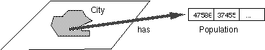
Are these isolated "spaceships", just "places"
floating around in a void? This is the model of social science
data: "cases" as places, and it doesn't allow spatial
relationships in any deep way. Coordinates can be represented
as variables, but that does not provide for the relationships...
Temporal examples:
Control:      Measure:
Time (hour)   Attribute (water level)   => strip chart (stream guage)
Poland@date   Location                  => Historic Poland
Real-time stream
data from USGS [moved, you have to navigate in to WA
watersheds); More real-time
data for atmospheric data; commercial
source of Radar image of rainfall
The Big Tradeoff
Historically, GIS developed in two tracks, two communities
of practitioners: Raster and Vector. The hardware was split, the
data were incompatible, the software had totally different capabilities.
Some research/development folks (ummm, like me) tried to assert
that one was "better" than the other. This is now treated
as a silly argument, a waste of time. Sinton, a raster person
figured out that the two approaches had a different model of the
world...
Both approaches provide a framework to allow a single value
at all points in a region. Geographically this is called a 'surface', mathematically a 'field', even
if the value is a category.
Time typically fixed for maps (otherwise they are diagrams...);
at best time can be a second control
based on relationships between location and attribute
Chrisman's revision/reinterpretation of Sinton
Object Frameworks (Vector)
basic rules: attribute serves as control, positions measured
to suit
- Isolated Objects:
each category taken as Yes/No
- 'Spatial
Object' (or cartographic feature view): each entity (point,line,area)
surrounded by the void
- Isoline:
continuous attribute sliced, disjoint
- Connected Objects: multinomial (more than one) categories
Space-Controlled (Raster / Grid)
- Point-based: center point
- Area-based: (many rules)
Relationship Control
- Control by Pairs (trade matrix; migration matrix, etc.)
- Triangular Irregular Network (TIN)
Composite Frameworks
- Choropleth (control by categories [names of zones] then by
space [irregular collection zone])
Rich example (result of some transformations): grid
of world population; more
about the World Population grid. This is a grid (space controlled)
that is trying to represent the TOTAL population correctly, estimated
from census sources (choropleth polygons)
Guide to Wall Maps displayed
(Sorry these are so big, they don't fit into any scanner, so
no web presence...)
- Historical Poland: The single category "Poland"
is fixed; calendar date acts as control; position of boundary
is measured. Colors depict areas that were part of Poland at
different periods. [Lithuania also shown, since King of Lithuania
became King of Poland]
- Peoples of Europe (the Doctor Professor Dietrich Schaefer
Dec. 1918) Time as a snapshot (more or less- 1918 was a bit complicated
with armistices, Russian Revolution, etc.); a given list of "peoples"
as control; boundaries measured. (Some areas classified as "mixed",
with sharp boundaries)
- Climatic Charts (USA) Shows average precipitation and temperature
by month at certain climate stations. Thus, location and time
controlled; two climate values measured (24 values per symbol...)
[Not all examples will fit the classification perfectly; prototype,
not Aristotlean]
- World Climates (Koeppen classifications) Time "fixed"
(irrelevant, post-Pleistocene); Classes come first, positions
of boundaries measured. [related to multi-dimensional criteria
on continua of precipiation and temperature, not pure categories...]
- Climate of North America, January Isopleth map . Time fixed
(or long term average, not emphasized); systematic set of thresholds
as control (contour interval: average temperature and January
temerature reduced to sea level [?]); location measured
- Seattle Street Map Isolated objects in a network. Time fixed;
category (road) as control; location measured. (Connectedness
matters, hence it is a network)
- Forests of France (two measurement frameworks)
- Percent of Population 16 and 17 years old enrolled in school
1960 (by county USA) [Paper map zero from Geog 360] Choropleth
map. Time fixed (1960 Census). Composite measurement: First
base map constructed with county NAME as control (position measured
for county boundaries), then county used as control to measure
a Census proportion of census columns [Note some counties have
insufficient denominator to justify the proportion.].
- Tactical Pilotage Chart (like many sources a mixture of many
measurement frameworks)
Index from Here: | Next
Lecture | Glossary
| Schedule of Lectures | Labs and Due Dates | How
to reach us
Version of 6 October 2003