Objectives of Lecture:
You don't get to obtain full resolution in space, time and attribute simultaneously. Some components must be sacrificed as less important. These components serve as "control" for obtaining the measurement of the more important component. In Sinton's scheme, one is fixed, one is controlled, the other is measured. This scheme works for many kinds of spatial data, but it is not enough. Sometimes "fixed" is a bit too strong; there are other possibilities where the control is more indirect or where multiple steps are involved. However, the "measured" component can usually be discerned.
Looking at a map may give the wrong impression. If you see the symbols (the color, the shapes, the sizes) that is the surface layer. Measurement framework is about how the map was made, the measurements behind the presentation...
Some may want to review the definitions
from the Glossary compiled
out of Exploring GIS
Spatial Object Single category distinguishes from void
Isoline Regular slices of continuous variable
Network Spatial objects connect to each other, form topology
Categorical Coverage Network formed by exhaustive classification
Center point Systematic sampling in regular grid
Systematic unaligned Random point chosen within cell
Extreme value Maximum (or minimum) of values in cell
Total Sum of quantities (eg. reflected light) in cell
Predominant type Most common category in cell
Presence / absence Binary result for single category
Percent cover Amount of cell covered by single category
Precedence of types Highest ranking category present in cell
Measurement by pair Control by pairs of objects
Triangular Irregular Network (TIN) Control by uniform slope
Choropleth Control by categories (name of zones) then by space
Measurements can be attached to spatial objects, based on overall characteristics of the class. This can be used to rank categories, or to assign interval or ratio values to a category. Such a step has to be justified by some impression that the value applies uniformly to the whole class. (Discussed further in Chapter 4 as the Evaluate operation; see Lecture 08)
        Control:    Measure:
First:  Attribute   Location  => Categorical Coverage (eg. soils or land use)
         (category)
Second: Category    Attribute => Estimate for category (eg. bushels Corn yield for soils category)
A composite has two even more distinct measurement phases, as in making a choropleth map:
        Control:    Measure:
First:  Attribute   Location  => Collection Zones (eg.  counties)
Second: Location    Attribute => Choropleth (eg. %  vote for Initiative 187)
Some composites can involve sums, averages, or other operations
(eg. largest
city in each county)
Behold the Forests of France; the map in the corner is "Density of Forests" (Percent of area covered by Forest) BY Department (the political subdivisions of France). The key is that the geometric objects, the lines, are political, not from the distribution of forests. It is a choropleth framework with a rule to aggregate the forests within each political unit by a sum of area.
What should the legend of the main map be? French Forests BY Forest. The spatial units come from the atribute forest, not imposed from outside.
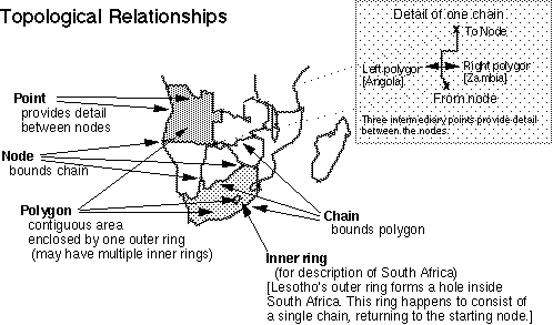
Topology: study of basic spatial relationships
based on intuitive notions of space
(those not requiring measurements - just dimensions)
[the higher levels of mathematics of space (collectively called
Geometry):
Graph theory adds direction (even distances) to a network (still
based on connectivity)
Analytical Geometry: coordinate measurements; metrics of distance,
orientation
Differential geometry: projections
In mathematics, there are two approaches to topology: combinatorial and "point-set". Viewed as a cartographer, combinatorial is about continuous space, while point-set topology is about set theory that breaks down to "atoms" of discrete points at some level of inspection. For all practical purposes, this difference isn't all that important, except to notice that mathematics has just the same split as the GIS trade between continuous space and screte space... Both approaches to topology build higher level objects from relationships.
The basic (more basic than length, area or anything involving numbers) spatial relationships: connectivity, contiguity
Some measurement frameworks avoid the need for topology if they are isolated (simple object frameworks) or if the spatial relationships are IMPLICIT (as in space controlled regular sampling systems - regular rectangular grids).
Connected coverages imply attention to topology.