Representation
Objectives of lecture:
- Models for representation: Raster & Vector
- Topology: focus on connectedness (relationships), not exact
measurements
Representation:
encapsulates measurements inside a system of control
(implements a measurement framework, but does not always match)
Primitives for representation:
Primitives for attributes:
Bits, bytes, words - structured into fields and records (rows
and columns?)
Shades of the Geographical Matrix
Primitives for space:
coordinates (measure of location)
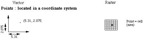
Vector: mathematical term for an element of an n-dimensional
space (projected onto the coordinate axes; here used for the direct
linear connnection between between two points - a holdover from
the storage screen era). Representation system permits coordinates
with seemingly infinite resolution.
Raster: a cellular model of geometry. Word derives from
mechanical sweep of cathode beam inside television tube and similar
devices. Becomes attached to resulting scan. Representation system
is clear about the limits of resolution (the cell).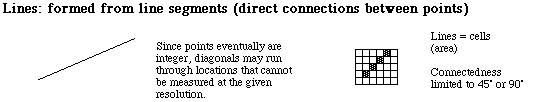
The Vector model can be used with `cartographic primitives' (point
line area) to represent isolated objects. Each object has its
geometric representation...
Connected coverages (networks & categorical coverages) require
deeper thinking.
Raster model directly implements space controlled measurement
frameworks, but can represent other measurement frameworks as
well.
Issues for raster representation:
- Resolution!
- Rules for aggregation
- Projections...
Teminology as explained by the software empire:
How ESRI explains vector
and raster.
They make the contrast
between these two as the organizing principle, though their vector
model is really just the isolated object framework.
Understanding Topology:
What it is NOT:
Topography: measurement/representation of earth elevation
and related features (a form of general/reference map)
Topology:
How USGS
refers to topology
[scroll down, it is the second thing that is "special"
about GIS].
- Adjacency is topological if things are connected.
- Containment is purely topological
- Proximity sounds much more metric (near, not far)
The basic spatial relationships: (an aliterative list)
- connectivity
- containment
- contiguity
- connectedness...
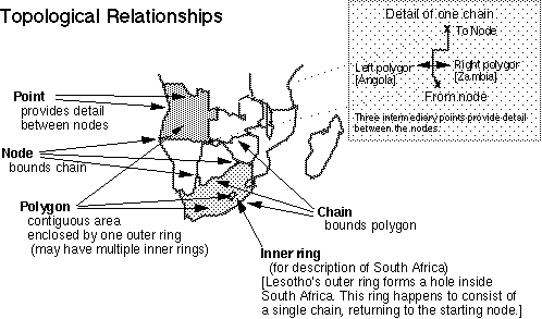
Structural relationships of the dimensional objects; mutually
constituitive; assemble a connected coverage
- points (nodes) bound lines
- lines (chains) bound areas
- areas (polygons / faces) bound volumes
Topological issues in data structures:
- logical consistency - more basic than positional accuracy
(see Data Quality lecture)
- error detection during digitizing (topic discussed in future lecture 18)
- Topology for networks
- Users CARE about connectivity
- Orientation of segments: upgrades from topology to graph
theory: direction of flow; rules about flow depend on what is
transported/linked (eg. water, electricity, data...)
- "Turn tables" (attributes of nodes or lines incident
at nodes)
- "Events": features (not necessarily temporal!)
linked to a position along a link in a network, may apply to
some segment of the "line"
- Planar versus non-planar graphs (treatment of underpasses,
etc.)
- Inner rings: the myth of a special problem (Isle Royale:
largest island in the larest lake in Nroth America)
- Old solution: "retraced lines"
- Shapefile solutions (components of objects) containment flags...
- Topological simplicity: polygon definitions
Attribute relationships (preview of Chapter 4):
Vector approach implies some form of attribute database to
attach to the geometric objects. The 'geographical matrix' rides
again, but there are relationships this matrix does not model.

Index from Here: Resources - See 465
(more advanced) course | Next Lecture
| Schedule of Lectures | Labs and Due Dates | How
to reach us
Version of 10 October 2003