Digitizing and How to Avoid it
Objectives of lecture:
- Digitizing as transformations
- Hardware measurement and representation
- Software control of relationships
- Practical issues of making databases
- Huge expenditures on conversion
- Data Quality issues
- Avoiding Digitizing: <Finding some one who has already
done it>
(Chapter 3)
GIS depends on data. In this early era of GIS adoption, that
data comes mostly from the 'conversion' of existing maps.
There are some nasty side effects of this process. The position
of a symbol on a map (the representation) may be controlled by
the original measurement of the corresponding 'feature', but it
may have been 'displaced' as a part of map compilation, generalization
etc [the sum of all the operations performed after the original
measurement].
The measurement frameworks used in traditional maps (such as contours)
may not match the measurement framework desired - thus transformations
are the core of the conversion process.
Digitizing hardware:
Vector tracing
normally using a hand-held cursor on a digitizing table. The
cursor is NOT a mouse. A mouse uses relative coordinates
(it doesn't move when you pick it up). The digitizer cursor measures
absolute location on the surface. When you plunk it down,
you move to that position...
Point mode/ stream mode; accuracy mostly controlled by skill of
operators and line weights, though the hardware may be accurate
to .005 or .003 inch.
Raster scanning
originally single sensor on
a drum, now push-broom CCD array map image converted into
measurement by pixel; image processing produces vector measurements
(edge detection, line following)
All digitizers produce coordinates in their local space (integers).
USGS GIS poster
Digitizing Software
Registration connects known points on the map image
to their intended location. Hidden in most software: a 'fit' computed
between measurements (more on this in lecture
on changing coordinate reference systems).
Topological structure: either the digitizing operator or the
software can create the relationships. Software for 'planar enforcement'
is essentially the overlay engine, applied in a different way.
(Remember the introduction to topology back in the Representation
lecture.)
Different strategies:
- bulk input, batch checking (eg. ARC Clean/Build)
- calculate intersections of the fly (eg. ROOTS)
- 'Heads-up' digitizing on the scanned image (eg. SmallWorld
GIS, ArcView with a TIFF image)
Verification and Quality Control:
either a lot of visual inspection, or use software to verify
relationships (integrity constraints) expected to occur - the
topological model for geometry; attributes verified by other relationships
(completeness from list of all objects) or brute force inspection.
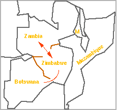
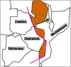
Examples of Digitizing Errors
a) Missing line
This case occurs by leaving out Lake Kariba, or coding it
as 'water' not 'international boundary'.
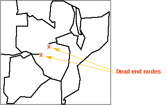
Undershoot
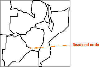
Overshoot
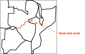
a) Multiple identifers
from undershoots or missing lines.
b) No identifier
from simple omission.
c) Extraneous linework
creates unlabelled polygons.
(Entering a railroad into the 'country' boundary network can create
extra 'countries'.)
How to Avoid Digitizing:
You can avoid digitizing by finding a source for the digital
database "somewhere" out there. This was a glimmer of
hope a few years ago, and a near-reality these days.
Data Policies Worldwide
Traditional map making institutions expect to play a leading
role in the future arrangements: Ordnance
Survey in UK (drill down in to see the copyright fees...)
and, until recently, the US Geological
Survey sees the future in National Cartographic Data Bases,
an inventory created by digitizing existing "topographic"
maps.
USGS has now changed its approach with a mission
much more directly oriented towards a digital future - now called
the National Map. see also the Web
GISData portal. [geography.usgs.gov not responding today,
sorry]
Policies about public access, cost recovery, copyright and other
legal issues vary widely.
This approach is fairly international but not the only possibility.
If digitizing is the current, transitional source of most GIS
layers, the eventual source will be some network of cooperating
systems. The USGS's role in the National
Spatial Data Infrastructure demonstrates this concept, based
on concepts originated by National Research Council Mapping
Sciences Committee (the 1993
report was the second on the topic). [NSDI is a component
of Al Gore's National Information Infrastructure - the infobahn].
The Federal Geographic Data Committee
is in charge of the development of the federal portion of NSDI,
but it really involves "partnerships" with local government
and all kinds of distributed actors (not a centralized single
production system).
Spatial Data Infrastructure (Geospatial Data Framework) projects
now abound, including an international group. The UK
had started up their own, among many copy-cats, it got turned
into AskGiraffe?.
In some places, the database will not just be populated with the
tired old maps. France (IGN)
plans to create BD-Topo
as a digital database (Completion
advancing slowly). This database is similar in many respects to
the City of Seattle Common Land Database, except that it is being
updated...)
[Resources on Data Marketplace and
Digitizing]
Index from Here: | Next
Lecture | To Transformation Lecture
| Measurement Framework Lecture
| Representation Lecture | Schedule
of Lectures | Labs
and Due Dates | How to
reach us
Version of 14 November 2003